Frequently Asked Questions
Govynnow Gorrys Menowgh
What does World Heritage Site / WHS mean?
Recognised by UNESCO, World Heritage Sites are places of significance and value to the whole of humanity. In terms of importance, this places the Cornwall and West Devon Mining Landscape World Heritage Site on a par with international treasures such as the Pyramids, Stonehenge and the Great Wall of China. Visit our What is a World Heritage Site? page to find more about the status.
How many Cornish Mining World Heritage Sites are there?
Just the one, but our World Heritage Site covers nearly 20,000 hectares and is made up of 10 distinct Areas across Cornwall and west Devon. Visit our Areas pages to find out more about our fantastic WHS.
Why have the mining landscapes of Cornwall and west Devon been designated a World Heritage Site?
Cornwall and west Devon’s mining landscape, shaped during a period of intense industrial activity, is testimony to one of the greatest periods of economic, technological and social development Britain has ever known.
From 1700 to 1914, the metal mining industry played a vital role in transforming our way of life. It provided essential raw materials to feed the Industrial Revolution in Britain, and pioneered technological developments that helped shape the society we live in today. For example, Richard Trevithick’s advances in steam engine technology – originally motivated by the need to pump water out of mines – ultimately enabled the development of steam trains, changing the world forever through the mass movement of people and goods.
This and other new engineering solutions and inventions developed here were exported to mining regions across the world – including Australia, the Americas and South Africa – playing a key role in the growth of an international capitalist economy. There are in excess of 175 places, across six continents, where Cornish mineworkers took their skills, technology and traditions creating a truly global heritage.
What does the WHS Office do?
Made up of a team of just 4, the WHS Office is tasked with a huge variety of responsibilities. These include: writing and delivering our Management Plan, commenting on approximately 900 planning applications within the Site annually, supporting and initiating conservation projects within the Site, outreach to the local and global community to tell the story of our mining culture in a variety of ways, supporting different research and cultural projects interpreting our site’s importance, education projects with local children to help them explore their cultural heritage, and of course celebrating our fantastic mining landscapes!
What is there to see in the WHS?
Ten separate Areas make up the World Heritage Site. Each has its own character, opportunities for adventure, and a different combination of the features that make up the Cornish Mining landscape.
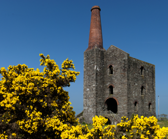
The WHS contains over 200 iconic Cornish engine house sites (the largest concentration of such monuments anywhere in the world). But Cornish Mining is about far more than mine sites – the mining industry impacted on all aspects of life. Many of our towns and villages were either transformed by a growing industrial population or newly built to house them. They reveal their history in the rows of distinctive terraced cottages, shops, chapels and substantial public buildings. Today you’ll find plenty of great cafés, pubs, restaurants, art galleries and museums.
The remains of the transport networks that were developed to serve the mines during the early 19th century – the railways, mineral tramways, canals, ports and quays – can now be explored by foot, bicycle or boat, making for invigorating and fascinating days out. Within the World Heritage Site you can find several of Cornwall’s great houses and gardens, paid for with the profits of the mining industry, now open to visitors.
What happened to Cornish mining?
Increasing competition through the expanding global mining industry reduced metal prices significantly during the latter half of the 19th century, forcing many local producers to close. Consequently, huge numbers of mineworkers migrated to mines elsewhere in Britain and overseas; Cornwall alone is thought to have lost between 250,000 to 500,000 people from around 1815 to 1915, the period defined as ‘the Great Migration’. Today there are an estimated six million-plus people worldwide descended from migrant Cornish mineworkers.
Cornish mining is currently going through a revival with Geothermal and Cornish Lithium exploration being undertaken. This new responsible mining has the potential to support green energy.
How can I help?
If you would like to support the Cornwall and West Devon Mining Landscape you can now become a member here. Not only will you help us to continue our valuable work but we will also share our in depth materials with you as a thank you in the member’s area. If you have a specific project you would like to discuss with us head to the contact page to get in touch with us.
Does the WHS comment on planning applications?
Yes. The World Heritage Site Office as a non-statutory consultee reviews a vast number of applications ranging from householder applications to major development schemes and provides comments to Cornwall Council as the Local Planning Authority (LPA) as necessary. Where we have submitted comments, these can be viewed under the 'consultee comments' section when searching the online planning register for a specific application on Cornwall Council’s website. West Devon Borough Council and Devon County Council monitor and comment on WHS related planning issues within the part of the Site in west Devon.
What is the role of the World Heritage Site Office in respect of planning matters?
The World Heritage Site Office is a non-statutory consultee with regard to planning policies and decisions and it influences the planning process in the following ways:
- Assistance in preparing Local Development Frameworks with Local Planning Authorities (LPAs) including district wide strategy and planning policy development.
- Prepares the Management Plan for the WHS, which sets out a range of planning related policies that Local Planning Authorities will consider when determining a planning application in the WHS or its setting - the surroundings in which a place is experienced, its local context, that will include present and past relationships to the adjacent landscape.
- Provides specialist advice to LPAs on individual planning applications within the WHS and its setting
How does the WHS affect planning?
The United Nations Educational, Scientific and Cultural Organisation (UNESCO) World Heritage Committee inscribes World Heritage Properties onto its World Heritage List for their Outstanding Universal Value (OUV) – cultural and/or natural significance which is so exceptional as to transcend national boundaries and to be of common importance for present and future generations of all humanity.
World Heritage Sites are defined as 'designated heritage assets' in the National Planning Policy Framework (NPPF).
In addition, relevant policies within the adopted WHS Management Plan, though it is not a part of the formal planning system, need to be taken into account by local planning authorities in developing their strategy for the historic or natural environment (as appropriate) and in determining relevant planning applications.
An online version of the World Heritage Site Management Plan (2020-2025) can be accessed via the following link: Management Plan
Will my proposed development affect the WHS?
Visit our Planning pages for more information on planning within the WHS. World Heritage Sites are inscribed for their Outstanding Universal Value (OUV). The World Heritage Site has seven defined physical 'Attributes' across ten separate landscape Areas (A1-A10), that together express its OUV. The seven Attribute types are as set out below.
Mine sites, including ore dressing sites
Mining (extraction) and ore dressing (processing) sites are the most obvious features within the historic mining landscape and are often accompanied by one or more of the iconic Cornish type engine houses.
Mine transport infrastructure
Transportation infrastructure was essential to convey imported coal, supplies and mineral ores to and from the mines. Many ports, harbours, mineral tramroads and railways were constructed in Cornwall and West Devon for this purpose.
Ancillary industries
The growth of mining in Cornwall and Devon fostered the creation of many industries ancillary to mining such as iron foundries and engineering works, gunpowder factories and tin smelters.
Mining settlements and social infrastructure
The employment opportunities offered by large scale development in the mining industry led to a rapid population growth and the emergence of new settlement patterns. Housing was built within existing market towns and villages and also within new settlements in the various mining districts.
Mineworkers’ smallholdings
Mineworkers’ smallholdings developed in the mining districts as a response to an increasing demand for land to rear animals and tend crops. These smallholdings, of often around two hectares (five acres), consisted principally of self-built cottages on holdings leased from the landowner. This ‘pig and potato’ subsistence husbandry brought an important degree of self-sufficiency to the mineworker.
Great Houses, estates and gardens
Mining wealth was used by influential landowners and shareholders (adventurers) to establish grand estates and gardens, many using specially imported plant species new to Britain.
Mineralogical and other related sites of particular scientific importance
Mineralogy, geology, and the practical application of these sciences to the mineral processing industries, were studied extensively in Cornwall and Devon in the nineteenth century. Key mineralogical sites within the WHS include the discovery sites of new species, the sources of world-class specimens, and important mineralogical exposures.
When considering development that might affect the OUV of the WHS, it is necessary to submit sufficient information to enable an assessment of potential impacts. This is done through a Heritage Impact Assessment (HIA) and sometimes forms part of Landscape Visual Impact Assessment (LVIA).
As a starting point it is important to consider what Attributes might be affected by your development either on site or in the wider area. Is information available about Attributes of OUV through historical and archaeological information, and what might the impacts be?
It is important to consider the impacts of the development in the context of not only the visual impact, but also in terms of the character of the settlement or landscape, the disruption to sites that are connected either physically or visually and also what improvements and compensatory benefits might help to lessen the impacts or better reveal features of the World Heritage Site.
Can I get further advice in relation to my development?
The World Heritage Site Management Plan (2020-2025) and its appendices provide a more detailed explanation as how development can impact upon the WHS and its setting and describe the extent of the Site and its Attributes of Outstanding Universal Value (or key features). The Management Plan also contains policies and strategic actions for the Site.
In addition to the Management Plan there is the WHS Supplementary Planning Document (SPD) that aims to unpick what makes the WHS important and provides advice on how the WHS should be taken into consideration in terms of the planning/development process.
The World Heritage Site Office also now provides a pre-application consultation service for planning schemes which are deemed to be major developments. You can access further details of this service via the following link: Pre-application advice service
I’m concerned about a planning application in the WHS. What should I do?
Your first point of contact should be the relevant LPA (Cornwall Council, West Devon Borough Council or Devon County Council). You may be able to see details and plans for the application on their website or otherwise at their offices. You will also be able to find out what other comments have been made about the application.
Someone is damaging or removing a feature in the WHS, is it protected?
Some features within the WHS may be Listed Buildings or Scheduled Monuments. As such they are protected from damage and demolition. There are also some restrictions in relation to demolition within Conservation Areas where it would exceed certain criteria. More information on demolition can be found on the Planning Portal via the following link: https://www.planningportal.co.uk/info/200130/common_projects/13/demolition
In other instances buildings and features do not benefit from such protections and therefore can be at risk through damage or demolition. Before attempting demolition you should consult with your LPA to ascertain if their prior approval is required.
Are hedgerows protected from removal?
The Hedgerows Regulations 1997 were made under Section 97 of the Environment Act 1995 and came into operation in England and Wales on 1 June 1997. They provide important protection by prohibiting the removal of most countryside hedgerows (or parts of them) without first notifying the local planning authority (LPA). ’Removal’ includes acts which could result in the destruction of a hedgerow. This is particularly relevant in those Areas of the WHS where mineworkers' smallholdings form a distinctive part of the landscape, as these field boundaries are part of one of the seven Attributes of that express the OUV of the WHS.
Where can I find out if my house is in the WHS?
The Cornwall and the Isles of Scilly's Historic Environment Interactive Mapping is a useful tool for checking whether your property or a site is within the WHS in Cornwall, while the Devon County Council Environment Viewer provides similar mapping for Devon.
The WHS Areas are viewable by switching on the appropriate layer and addresses can be searched by using post codes.
Historic Ordnance Survey mapping is also available for circa 1880 and circa 1907, so that you can see your site as it looked over 100 years ago.