Why is the World Heritage Site important?
World Heritage Sites are very special places. They are inscribed by the United Nations Educational, Scientific and Cultural Organization (UNESCO) for their ‘Outstanding Universal Value’ (OUV), or international importance, to the whole of humankind. World Heritage Site status is the most important heritage designation internationally.
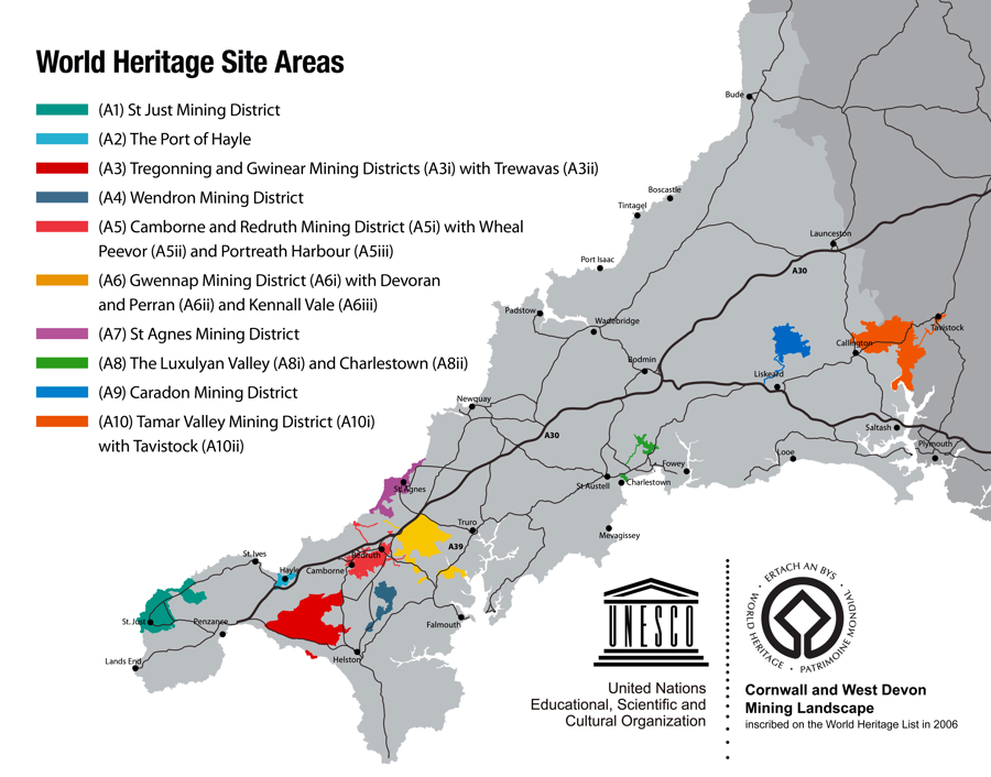
The Cornwall and West Devon Mining Landscape World Heritage Site, or Cornish Mining WHS, is defined by individual Attributes of OUV, i.e. particular historic features in the landscape which have a defined link with local metal mining during the period 1700 to 1914. These Attributes can be found throughout the WHS which consists of ten separate Areas numbered A1 to A10 (please see the WHS Areas map below to see the locations of these). Together these internationally important Attributes express the OUV of the World Heritage Site and are as described in the illustrated list in Section B.
Will the World Heritage Site affect my development project?
Not all development projects will be affected by the WHS as your location may be beyond the Areas shown on the map but, for those sites that are within or nearby, consideration is required to determine how a project might impact on, or be shaped by, any heritage features present. The purpose of this guidance is to help you find out if there might be WHS implications for your development and, if so, whether this should be designed in such a way as to avoid causing harm to it.
When making a development application it is necessary to submit enough information to the local planning authority to enable it to undertake an adequate assessment of all potential impacts. This can be achieved by the planning applicant or their agent commissioning a contractor to prepare a Heritage Impact Assessment (HIA). Whilst usually a separate study, these can sometimes incorporate or form part of a Landscape Visual Impact Assessment (LVIA) or a Design and Access Statement (DAS). The LVIA should set out how the project might affect important views between Attributes or between adjoining Areas of the WHS. A DAS should demonstrate how the findings of the HIA study has informed and shaped the final design. If you would like further information on the format of the above studies, please contact the World Heritage Site Office at: whsplanning@cornwall.gov.uk
Is my development within, or adjacent to, the World Heritage Site?
In considering if the WHS might affect your development project, first check if your site is in, or near, one of the WHS Areas. Digital mapping, available free to the public online, identifies the ten Areas of the WHS and can show if your site includes, or is near, any WHS Attributes of OUV. This is explained further in Section B. The online mapping also gives details of listed buildings and scheduled monuments as well as other designated landscapes, such as Conservation Areas and Areas of Outstanding Natural Beauty (AONBs), should any of these relate to your project.
Historic and modern mapping, and other information, is available online at both the Cornwall Council and Devon County Council websites. Please follow the web links below to view;
Cornwall Council Interactive Mapping: https://www.cornwall.gov.uk/community-and-living/mapping/
Devon County Council Environment Viewer: https://www.devon.gov.uk/historicenvironment/projects/national-mapping-project/
Explanations of designations can be found via the links below;